Heritage
History of Elizabeth
How a 1891 streetcar plat east of uptown became Charlotte's second-oldest neighborhood — and nearly lost itself before it was saved.
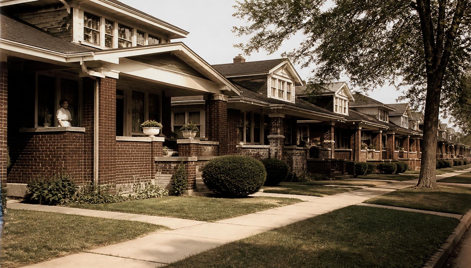
Elizabeth's history is unusually legible for a Charlotte neighborhood, because almost all of it is still visible on the ground: the streetcar-era plat, the bungalow blocks that filled in behind it, the park set aside as the city's first, the boulevard that cut across its eastern flank, and the designation that eventually protected what survived. Reading the neighborhood today means reading these layers in order.
1891: The plat and the streetcar
Elizabeth was laid out in 1891 as a residential suburb served by Charlotte's early streetcar line, which made it possible for the first time for a household to live a genuine distance from uptown and still commute to work downtown daily. That single fact — transit access without a horse-and-buggy commute — is why Elizabeth exists as a distinct neighborhood at all rather than as farmland absorbed later into the city grid. It is Charlotte's second-oldest neighborhood, trailing only Fourth Ward, and its street grid still traces the logic of that original streetcar-suburb plan: a spine road (what became Elizabeth Avenue) with residential streets branching off it.
The naming, and Elizabeth College
The neighborhood's name is generally connected to Elizabeth College, a women's college that opened in the area in its formative years and gave the district both its identity and, for a period, its civic anchor. Local historical accounts vary on the exact reasoning behind the name, and readers researching the point in depth should consult the Robinson-Spangler Carolina Room's local history holdings rather than take any single popular account as definitive. The college itself did not survive in its original form into the later twentieth century — it merged and relocated over subsequent decades — but the name outlived the institution, attached now to the neighborhood, its main commercial street, and its avenue.
1900s–1920s: The build-out
The bulk of the housing stock that defines Elizabeth today was built in a roughly 25-year window bracketed by the streetcar's extension on one end and the onset of the Depression on the other. Craftsman bungalows, American Foursquares, and Colonial and Dutch Colonial Revival houses went up on the platted lots, block by block, as Charlotte's professional and merchant class moved out from the crowded uptown core. Presbyterian Hospital — now Novant Health Presbyterian Medical Center — established itself on the neighborhood's western edge during this period as well, beginning a relationship between Elizabeth and institutional healthcare that has never really ended and today still shapes traffic, parking, and land use along that boundary.
Independence Park, set aside as Charlotte's first public park, was also taking shape during this window, giving the neighborhood's interior blocks a green anchor that still functions exactly as originally intended: a shared lawn and pond within easy walking distance of nearly every house in the district.
Related reading
Mid-century: Decline and the boulevard cut
Elizabeth's fortunes softened in the decades after World War II, following a pattern common to streetcar-era neighborhoods across the country. As the streetcar system itself was phased out and automobile suburbs opened up further from the center, in-town neighborhoods with aging housing stock lost buyers to newer subdivisions. Many of Elizabeth's larger houses were subdivided into rental units during this period, and deferred maintenance became common.
The most visible scar from this era is Independence Boulevard, a mid-century arterial cut through the neighborhood's eastern edge that removed houses, severed at least one street pattern, and left a hard automobile-scaled boundary where a residential grid had run continuously before. The boulevard remains today a clear dividing line on any map of the district, and its presence is one reason the eastern edge of Elizabeth feels different in character from the interior blocks around the park.
1970s–1980s: Reinvestment
Elizabeth's recovery, like that of several other in-town Charlotte neighborhoods, was driven by residents and buyers who recognized the value of the bungalow and Foursquare stock while it was still comparatively inexpensive, and who began systematically restoring rather than replacing it. This grassroots reinvestment, running through the 1970s and into the 1980s, is the reason the neighborhood's original housing survived in such volume rather than being cleared for denser redevelopment, as happened to comparable streetcar suburbs elsewhere in the Southeast.
Designation and the present day
That reinvestment culminated in formal recognition: Elizabeth secured listing on the National Register of Historic Places and, separately, designation as a local historic district under the City of Charlotte's ordinance, which brought design review to exterior changes visible from the street. Today the neighborhood functions as a small, walkable, historically coherent in-town district bordered by a major medical campus, a community college along Elizabeth Avenue, and Independence Boulevard — a living record of every layer described above, still legible from any porch on nearly any block.
Heritage
Continue through Elizabeth's heritage
Designation rules, architectural styles, the bungalow form, and the institutions that shaped the district.
Buying into that history
Owning a piece of Elizabeth's history comes with real obligations and real rewards
A century-old house in a designated district is not the same purchase as a newer home across town. Peters & Associates can walk you through what a specific house's history means for your renovation and resale plans.
Charlotte Real Estate
Peters & Associatesyourleaderinluxury.comAdvertising disclosure. This is a paid or affiliated relationship: the firm above is affiliated with or compensates the publisher of this independent guide, and contacting it may result in a commercial engagement. It does not buy editorial placement. Full disclosure.
Questions & Answers
Frequently asked questions
Direct answers to what readers most often ask about this section of the guide. Each answer cites the primary source it rests on.
All Elizabeth questions →When was Elizabeth founded?
Elizabeth was platted in 1891 as a streetcar suburb east of what was then the edge of Charlotte, making it the second-oldest neighborhood in the city after Fourth Ward. The plat followed the extension of a mule-drawn, later electric, streetcar line out from uptown.
Source: City of Charlotte tree canopy and tree ordinance program
Where does the neighborhood's name come from?
The name is generally tied to Elizabeth College, a women's college that anchored the area in its earliest years, though multiple local accounts exist about the precise naming. Elizabeth Avenue, the neighborhood's commercial spine, carries the same name today.
Why does Independence Boulevard cut through the area's history?
The mid-twentieth-century construction of Independence Boulevard sliced through the eastern edge of the neighborhood's original footprint, removing houses, severing streets, and accelerating the disinvestment that already-aging bungalow blocks were experiencing. It remains the clearest physical scar of that period on the map.
Source: City of Charlotte tree canopy and tree ordinance program
When did Elizabeth become a historic district?
Elizabeth secured both National Register of Historic Places listing and local historic district designation from the City of Charlotte, following a period of grassroots reinvestment in the 1970s and 1980s. Local designation is the one that carries ongoing design review; the National Register listing is primarily honorific.
Is Elizabeth College still standing?
No original Elizabeth College campus building survives in the neighborhood today; the institution and its site went through mergers and relocations in the early twentieth century. Its legacy persists mainly in the neighborhood's name and in local-history references, not in a standing structure.
What caused Elizabeth's decline in the mid-twentieth century?
Like many streetcar-era neighborhoods nationally, Elizabeth lost ground as the streetcar system itself was dismantled, automobile-oriented suburbs pulled buyers further out, and large old houses were subdivided into rentals. Highway construction and shifting hospital and institutional land use added further pressure before reinvestment took hold.
Source: City of Charlotte tree canopy and tree ordinance program
Our Sources
How this page was researched
This guide is independently written and verified against primary public records and official organizations. It is not affiliated with, endorsed by, or representing any neighborhood association, hospital, college, school district, or governing body.
Read our full citation methodology and editorial standards- 01Local history collections and archives
Charlotte Mecklenburg Library — Robinson-Spangler Carolina Room
Historical record of the neighborhood's founding and growth.
- 02Survey and designation records for Charlotte's historic neighborhoods
Charlotte-Mecklenburg Historic Landmarks Commission
Historic designation, survey history, and landmark property records.
- 03National Register of Historic Places listings in North Carolina
NC State Historic Preservation Office
National Register district listings and nomination documents.
- 04Local historic district design standards and review process
City of Charlotte Historic District Commission
Certificate of Appropriateness requirements for exterior work.
Figures such as pricing, assessments, business hours, and school assignment change over time. Always confirm current details directly with the source before making a decision.
Topic Cluster
Elizabeth History & Architecture
How a women's college, a streetcar line, and a park made a neighborhood.
The Elizabeth Guide — Elizabeth History & Architecture →The Elizabeth Historic District
Designation, boundaries, and what review means before you touch a façade.
Continue →Elizabeth Architecture
Reading Craftsman, Colonial Revival, foursquare, and Tudor detail on one street.
Continue →Independence Park
Charlotte's first public park — history, features, and how residents use it.
Continue →Churches & Institutions
The sanctuaries, schools, and civic buildings that anchor the neighborhood.
Continue →Local Expertise
Work with the firms behind this guide
Last reviewed August 1, 2026. This guide keeps no contact form and no inbox — inquiries go directly to the firms below.